Geospatial data is any information that is linked to a specific location on Earth. It can represent the location of a building, a road, a pollution site, or any other object. This data not only includes geographic coordinates but may also contain additional information such as area, land type, population, and more. Thanks to geospatial data, we can better understand the world around us, enabling us to make smarter decisions in our daily lives.
Learn more: Geographic Information System (GIS) – Part 1.
To turn those ideas into reality, the first thing we need to do is provide GIS with a rich source of data—this is known as geospatial data. Simply put, geospatial data is any information that is linked to a specific location on Earth.
For example, it may represent the location of a building, a road, or a pollution site. This data does not only include geographic coordinates but can also contain additional information such as area, land type, population, and more.
Today, there are many open and free geospatial data sources that provide an enormous repository of information for researchers, planners, and geography enthusiasts. Some notable sources include Natural Earth Data, ESRI Open Data, USGS Earth Explorer, OpenStreetMap, and NASA’s Socioeconomic Data and Applications Center (SEDAC).
Learn more: Natural Earth Data
This is a vast repository of data for anyone interested in exploring geospatial information. With millions of datasets on terrain, climate, population, and more—regularly updated—Natural Earth Data is a valuable resource for researchers, planners, and map enthusiasts.
In particular, the open license of this dataset allows users to freely create, modify, and share their own products.
Learn more: ESRI Open Data
With more than 67,000 datasets, ESRI Open Data provides an extensive source of information for researchers, planners, and geography enthusiasts. From satellite data to population data, a wide variety of datasets can be found here. Its intuitive and user-friendly interface allows users to quickly search for and download the data they need.
This system is managed and operated by the world’s largest commercial GIS software company and includes open datasets from over 4,092 organizations worldwide.
Learn more: USGS Earth Explorer
With its intuitive and user-friendly interface, Earth Explorer allows users to easily search for and download millions of satellite images from around the world. From the well-known Landsat satellites to the modern Sentinel satellites of Europe, Earth Explorer provides a rich repository of high-resolution and high-quality data.
Beyond simply providing data, Earth Explorer also supports users in performing basic analyses such as calculating vegetation indices, measuring areas, and creating maps. With Earth Explorer, users can explore environmental changes, monitor natural phenomena, and build predictive models.
Learn more: OpenStreetMap
Built and maintained by a large global community of users, OpenStreetMap provides an open, detailed, and continuously updated source of geographic data.
With OpenStreetMap, users can access a vast amount of information about streets, buildings, public places, and much more. This data is encoded in vector format, allowing users to perform spatial analyses accurately and efficiently. Notably, OpenStreetMap is particularly strong in describing urban details, pedestrian and cycling routes, as well as points of interest such as restaurants, cafés, and tourist attractions.
Learn more: SEDAC
NASA’s Socioeconomic Data and Applications Center (SEDAC) is a valuable repository of data on the interaction between humans and the environment, providing a large collection of global socio-economic datasets. Covering a wide range of topics—from agriculture and climate to health and urbanization—SEDAC is an important resource for researchers, policymakers, and non-governmental organizations.
SEDAC’s data can be applied across many different fields, from assessing the impacts of climate change to planning sustainable urban development.
For example, researchers can use data on population, income, and land use to build models that forecast urban growth and demand for public services. Policymakers can also use disaster and risk data to develop response strategies and risk-reduction plans.
Maps are a powerful visualization tool that help us explore the relationship between data and geographic space in an intuitive way. Displaying data on maps allows us to better understand information, turning dry numbers into something more vivid and easier to interpret.
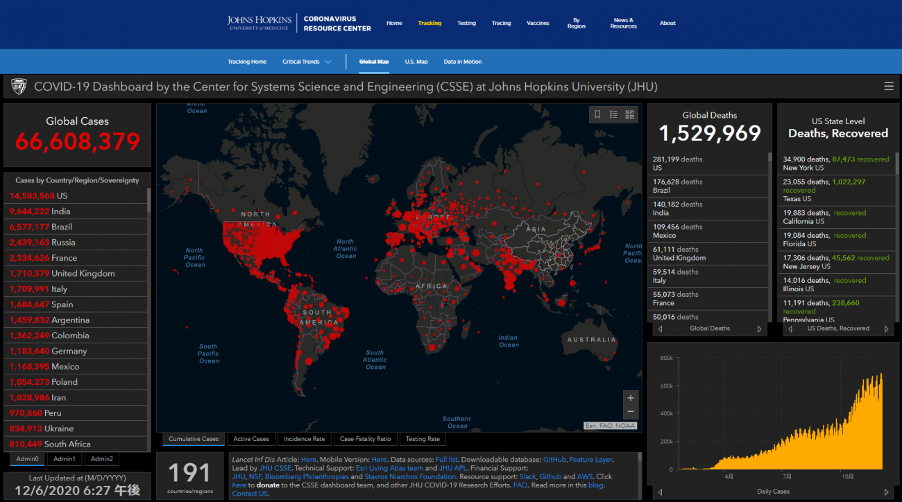
The COVID-19 pandemic in 2020 clearly demonstrated the power of maps in visualizing the spread of infectious diseases. Thanks to regularly updated maps, people were able to easily track the pandemic situation across different regions of the world.
Academic institutions and media organizations used maps as an effective tool to illustrate the scale and speed of the spread of the novel coronavirus, helping the public better understand the global pandemic situation.
Data plays an important role in making business decisions. By analyzing a wide range of market data, businesses can identify the areas with the highest potential to generate profit.
Selecting suitable locations for harnessing natural energy has become an urgent issue in the context of global climate change. Thanks to the development of geospatial technologies and modern data analysis tools, we can accurately assess the energy potential of different locations, enabling more effective and sustainable investment decisions.
Positioning technology is not limited to finding routes within cities; it is also being expanded to analyze routes across various terrains, providing optimized solutions for users in many different fields. By analyzing large volumes of data on traffic, terrain, and weather, navigation systems such as Google Maps are becoming increasingly intelligent and useful.
GIS data, with its diversity and richness, provides a solid foundation for building and developing GIS applications. From visualizing data to better understand social issues, to supporting decision-making in business and planning, GIS has proven its important role. With the continuous development of technology, GIS is expected to bring even more new applications, opening up endless possibilities for research, management, and sustainable development.
Are you facing challenges in implementing BIM for your project? Do you need support to optimize your BIM workflows? Or are you looking to enhance your knowledge of BIM and related technologies?
Don’t worry — BIMCAD Vietnam is always ready to support you!